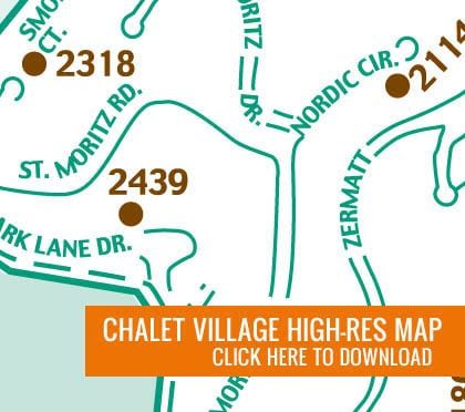
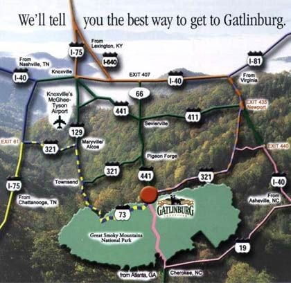
Welcome to the area maps section of our website. Here, we offer several maps to help guide our visitors before and during their stay at our Smoky Mountain cabin rentals. When you stay at one of our chalets in Tennessee, the last thing we want is for you to get lost. We have several high-resolution maps available for you to download. The map of the entire Chalet Village is the most useful during your stay. On this map, you will pinpoint the cabin you are staying in and what is nearby. Use this handy map during your vacation to plan out some of your adventures and to locate the sights you don’t want to miss. We also have a traffic map to help you locate Chalet Village, as well as a Gatlinburg area map. Below our maps, you will find directions to Chalet Village and Gatlinburg. We hope these directions and maps will make your trip worry free.
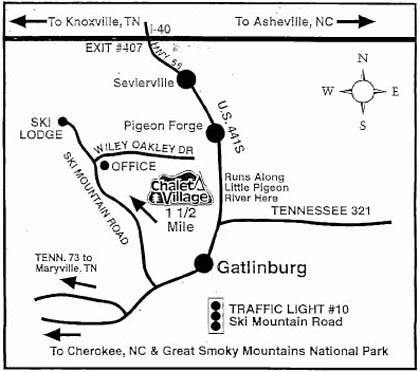
Directions to Chalet Village
From I-40: Take the Highway 66 Exit #407 to Sevierville, then follow 441 south through Pigeon Forge and Gatlinburg. In Gatlinburg, turn right at Traffic Light Number 10 (Ski Mountain Road). Follow Ski Mountain Road up approximately 1 1/2 miles and turn right on Wiley Oakley Drive. The Chalet Village office is on your immediate right.
From 441 North (Cherokee, NC): Follow 441 North through the mountains into Gatlinburg. Turn left at Traffic Light Number 10 (Ski Mountain Road). Follow Ski Mountain Road up approximately 1 1/2 miles and turn right on Wiley Oakley Drive. The Chalet Village office is on your immediate right.
Directions to Gatlinburg
Traffic in the Smokies can get heavy, especially along Highway 66 during peak travel seasons. (July and October are the highest travel months.) Take one of these less traveled and scenic routes to Gatlinburg and you’re well on your way to the perfect mountain getaway.
From Virginia: Take I-81 South to I-40 East to exit 435 (Newport) and follow Highway 321 South all the way into Gatlinburg. Approximate drive time from interstate: 45 min.
From Lexington: From Knoxville take I-75 South to I640 East to I-40 East to exit 435 and follow Highway 321 South. Approximate drive time from interstate: 45 Min.
From Chattanooga: Take Exit 81 on I-75 North and follow Highway 321 North to Gatlinburg through Maryville and Townsend. Approximate drive time from interstate: 1 hour and 10 minutes.
From Nashville: Take I-75 South to exit 81 and follow Highway 321 North to Gatlinburg through Maryville and Townsend to Gatlinburg. Approximate drive time from interstate: 1 hour and 10 minutes.
From Ashville: Take I-40 West to Exit 440 and follow Highway 321 south to Gatlinburg. Approximate drive time from interstate: 45 Minutes.
From Atlanta: Take I-85 North to I-985 North to Us 23. Take US 23 to Highway 23/441 to Highway 74/441 through Cherokee, NC, to Gatlinburg. Approximate drive time: 4 hours and 10 minutes.